Bridging the Gap: Integrating BIM with GIS for Enhanced Project Management
Table of Contents
In today’s rapidly evolving construction and infrastructure development landscape, the integration of technology has become a pivotal aspect of ensuring efficient project management and decision-making. Two of the most powerful tools in this domain are Building Information Modeling (BIM) and Geographic Information System (GIS). By combining these two technologies, we can unlock new possibilities and efficiencies in construction projects. In this article, we will explore the integration of BIM with GIS, its significance, benefits, and how it can be implemented effectively in BIM projects.
Understanding BIM Services and BIM Projects
Before delving into the integration of BIM and GIS, let’s briefly understand what BIM services and BIM projects entail.
BIM Services: BIM services encompass a range of processes and tools used for creating and managing digital representations of physical and functional characteristics of a building or infrastructure project. These services enable stakeholders to collaborate efficiently throughout the project lifecycle, from design and construction to operation and maintenance.
BIM Projects: BIM projects refer to construction or infrastructure development endeavors where BIM methodologies and technologies are applied. These projects leverage BIM services to improve collaboration, reduce errors, and enhance decision-making, ultimately leading to better project outcomes.
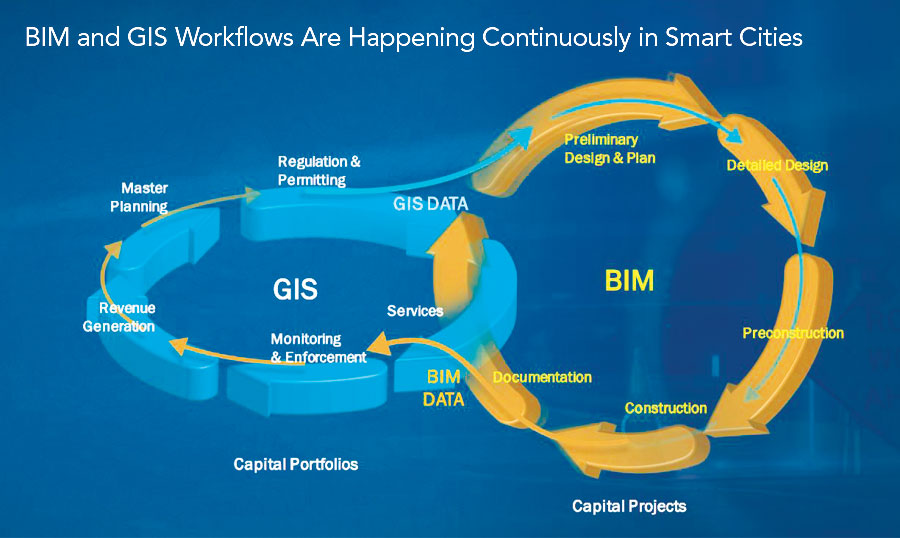
The Power of BIM-GIS Integration
Spatial Context for BIM Data:
One of the primary advantages of integrating BIM with GIS is the ability to provide a spatial context for BIM data. GIS excels in managing geographic and spatial information, which complements the detailed structural and design data in BIM models. This integration allows project stakeholders to visualize BIM data within the broader geographical context.
For instance, in urban planning, BIM models can be integrated with GIS to understand how new developments will impact the surrounding environment, including transportation networks, utilities, and land use. This holistic view enables better decision-making, reduces conflicts, and enhances project sustainability.
Site Analysis and Selection:
GIS provides powerful tools for site analysis and selection. By integrating GIS with BIM, project teams can assess potential sites more comprehensively. GIS can provide information on factors like environmental conditions, accessibility, and zoning regulations. This data can inform early-stage design decisions in BIM projects, improving project feasibility and reducing risks.Furthermore, GIS can assist in identifying suitable locations for temporary facilities during construction, optimizing logistics and resource allocation.
Facility Management and Maintenance:
Beyond the construction phase, the integration of BIM with GIS continues to add value. GIS can be used to create interactive facility management systems that overlay BIM data with real-time information about the facility’s location. This is particularly useful for large complexes, such as airports or hospitals.
Facility managers can access information on maintenance schedules, equipment locations, and even track the movement of personnel within the facility. This integration streamlines maintenance and improves the overall efficiency of facility management.
Implementing BIM-GIS Integration
Now that we’ve established the significance of integrating BIM and GIS, let’s explore how to implement this integration effectively in BIM projects.
Data Standardization:
To ensure seamless integration, it’s crucial to standardize data formats and protocols across BIM and GIS systems. Industry standards like Industry Foundation Classes (IFC) for BIM and Geography Markup Language (GML) for GIS can be employed. This ensures that data can be exchanged and interpreted accurately.
Interoperable Software:
Invest in interoperable software solutions that support both BIM and GIS functionalities. Popular platforms like Autodesk’s BIM 360 and Esri’s ArcGIS offer integrations that facilitate data exchange between the two systems. Training your team to use these tools effectively is essential.
Collaboration and Communication:
Effective collaboration and communication between stakeholders are key to successful integration. Project teams should include experts in both BIM and GIS who can bridge the gap and facilitate the flow of information. Regular meetings and documentation of workflows can help in this regard.
Data Quality Assurance:
Maintaining data accuracy and consistency is critical. Establish processes for data quality assurance and validation. Regularly update spatial and BIM data to reflect changes in the project, ensuring that decisions are based on the most up-to-date information.
Scalability:
Consider the scalability of your BIM-GIS integration. As the project evolves, the integration should be able to accommodate additional data and functionalities. Planning for scalability from the outset prevents disruptions in project workflow.
Benefits and Future Trends
The integration of BIM with GIS offers numerous benefits to BIM projects:
- Improved Decision-Making: Enhanced data visibility and spatial context lead to better-informed decisions, reducing costly errors.
- Efficient Resource Management: Optimized site selection and resource allocation improve efficiency throughout the project lifecycle.
- Sustainability: The ability to assess environmental impacts in real-time promotes sustainable design and construction practices.
- Enhanced Facility Management: Post-construction, facility managers benefit from streamlined maintenance and operations.
Looking ahead, the integration of BIM and GIS is likely to become even more sophisticated. Artificial intelligence and machine learning will play a role in automating data analysis and decision support. Additionally, augmented reality (AR) and virtual reality (VR) applications could provide immersive experiences for project stakeholders.
Conclusion
The integration of BIM with GIS represents a significant advancement in the field of construction and infrastructure development. By harnessing the power of spatial information and detailed BIM data, projects can be planned, executed, and managed with greater precision and efficiency. As technology continues to evolve, we can expect even more innovative solutions to emerge, further enhancing the synergy between BIM and GIS in the years to come. For now, embracing this integration is a step toward a brighter and more sustainable future for the construction industry.